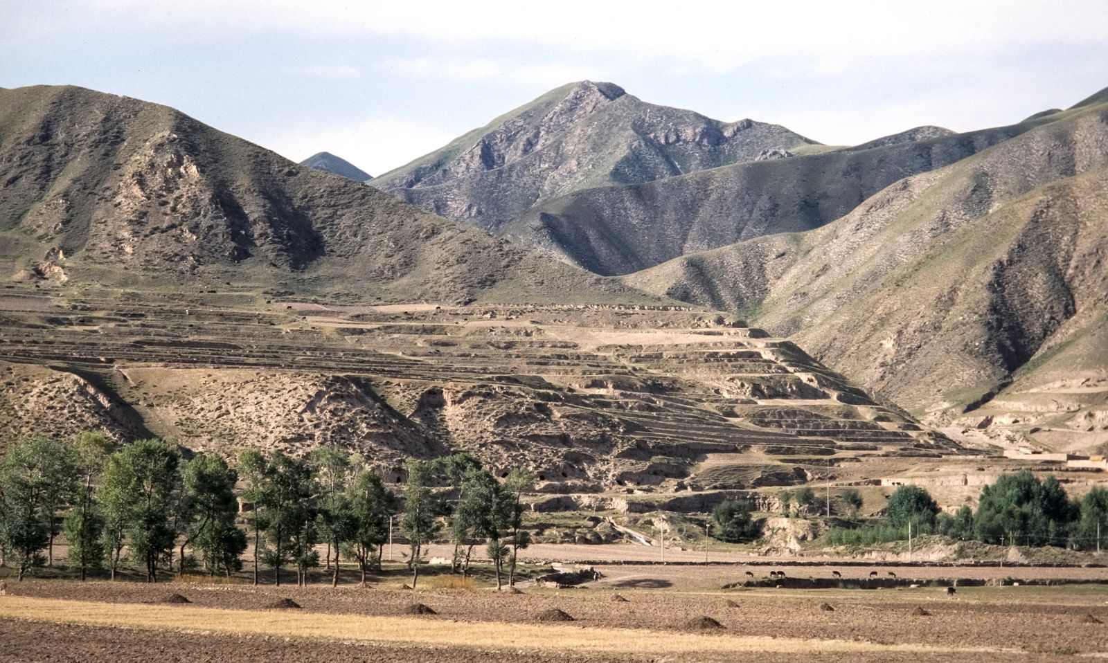
The answer is the Loess Plateau and a 60-year accumulation of earthworks, farming changes and vegetation restoration, not one sudden tree-planting campaign. Terraces slowed runoff, check dams caught sediment inside gullies, reservoirs intercepted what escaped, grazing controls gave grasses and shrubs time to return, and the Grain for Green programme later took steep cropland out of production. At Tongguan on the Yellow River, the annual sediment load fell from about 1.6 billion tonnes in the 1970s to about 300 million tonnes in the period examined by researchers, a decline of more than 81 percent, while a 60-year attribution study found that human interventions were the dominant cause.
The Loess Plateau spreads across roughly 640,000 square kilometres of north-central China, an area comparable to France. Nearly 90 percent of the Yellow River’s sediment once came from this region, but the land that produced it was also home to tens of millions of people. Any workable answer therefore had to hold soil on the hills without removing the farms, grazing land and villages that depended on those hills.
China’s answer was built in layers. Large conservation works were already reducing sediment decades before the 1999 launch of Grain for Green, and the later greening programme accelerated a change that terraces, dams and watershed projects had begun. The result was not the restoration of a pristine forest. It was the construction of a new erosion-control landscape.
A landscape built from airborne dust
Loess is fine mineral dust carried by wind and deposited in thick, porous blankets. In northern China, repeated glacial cycles laid down layer after layer. A landmark study dated a 330-metre loess sequence near Lanzhou and found that deposition there reached back roughly 2.4 million years.
Those alternating bands of yellow loess and darker fossil soils form one of Earth’s great terrestrial climate archives. Coarser grains mark periods of stronger winds; buried soils record warmer, wetter intervals when vegetation held the surface in place. A road cutting through the plateau can expose a vertical history of the East Asian monsoon.
The same structure makes disturbed loess exceptionally vulnerable. The material can stand in near-vertical walls while dry, yet bare slopes break apart rapidly under intense summer rain. Cultivation loosens the surface, livestock remove protective cover, and water gathers in channels that lengthen into gullies.
Once mobilised, the pale sediment enters tributaries and then the Yellow River. Far downstream, part of it settles inside the channel, historically forcing communities to contain an elevated river between dikes. The remainder travels toward the Bohai Sea, carrying the plateau grain by grain toward the coast.
The decline began before Grain for Green
The gauge record makes the chronology clear. Sediment transport was already falling before 1999, which means Grain for Green cannot explain the entire change. A synthesis of the measurements found that the annual load declined from approximately 1.6 billion tonnes in the 1970s to approximately 300 million tonnes, while average vegetation cover across 12 major plateau catchments rose from 25 percent in 1978 to 46 percent in 2010. The same analysis attributed the outcome to a changing mixture of engineering, vegetation and reduced runoff.
From the 1970s through the 1990s, terraces, check dams and reservoirs did most of the measurable work. Terraces shortened slopes and reduced the speed of surface flow. Dams turned narrow gullies into sediment traps. Reservoirs intercepted material that reached larger channels.
Vegetation restoration became more influential from the 1990s onward. Roots strengthened the upper soil, stems and leaf litter softened the impact of raindrops, and rougher ground slowed water long enough for more of it to soak in. The engineering and the plants reinforced each other, but neither acted alone.
A major bridge between the two phases was the Loess Plateau Watershed Rehabilitation Project. According to the World Bank’s project assessment, its first phase ran from 1994 to 2002 across 1.56 million hectares in 21 counties. The work included 90,500 hectares of terraces, 90,900 hectares of afforestation, 136,000 hectares of shrubs, 100,140 hectares of grassland and thousands of sediment-control structures.
How the plateau was rebuilt one slope at a time
Terracing changed the geometry of farming. Instead of ploughing directly up steep, erodible slopes, farmers concentrated crops on flatter steps where rainwater moved more slowly. The more reliable fields also made it possible to retire the most fragile land without removing food production entirely.
Check dams dealt with the sediment after it entered a gully. Each low barrier caught a pulse of mud and allowed water to continue downstream with less of its load. As silt accumulated behind successive dams, some former gullies became flat plots of deep, fertile soil. Researchers estimate that about 60,000 sediment check dams have been built across the plateau.
Grazing controls protected the work between the gullies. Sheep and goats that had roamed freely were increasingly penned or moved away from recovering slopes. Grasses and shrubs could then regenerate without every new shoot being eaten, while stall-fed animals became part of a more intensive farm system.
The results inside the World Bank project areas were measurable. Perennial vegetation cover rose from 17 to 34 percent, sediment entering the Yellow River fell by more than 100 million tonnes a year, and per-person grain output increased from 365 to 591 kilograms during the second project period. The World Bank’s results summary also reported that household incomes increased from about $70 to about $200 per person.
This work was expensive, even before the national greening programme expanded it. The first World Bank project cost $252 million, while financing listed for the second totalled another $239 million. Like South Korea’s post-war forest recovery, the plateau’s change depended as much on rural livelihoods, enforcement and long-term public spending as it did on seedlings.
The programme that turned grain fields green
Grain for Green, also known as the Sloping Land Conversion Programme, began in 1999 and pushed revegetation across a far larger area. Farmers received support for converting erosion-prone cropland into forest or grassland. By the time of a 2016 assessment, the programme had converted about 16,000 square kilometres of rain-fed cropland on the plateau and produced a 25 percent increase in vegetation cover over the preceding decade. That Nature Climate Change study described the plateau as a uniquely large experiment in planted vegetation.
The payments were not marginal. By the end of 2014, more than 45 billion yuan had been invested across three plateau provinces, including 36.69 billion yuan in grain subsidies and 6.62 billion yuan in direct grants. A regional assessment of Grain for Green found that an average of 2.72 million rural households a year participated between 2001 and 2013.
The colour change was large enough to measure from orbit. Vegetation indices derived from repeated satellite passes recorded expanding cover through the 2000s and 2010s, while ground surveys followed changes in soil and farm production. The ability to combine frequent Sentinel-2 observations with Landsat’s longer record, as Space Mart has reported in its coverage of harmonised Earth monitoring, now gives researchers a sharper view of where greening persists and where it falters.
Much of the successful cover was not dense forest. In the drier north, grasses and shrubs can protect soil with a smaller water demand than thirsty tree plantations. Orchards and other economically useful plantings also mattered because farmers were more likely to maintain vegetation that continued to support a household.
The green surface has a water bill
Every additional leaf increases the surface area through which water can return to the atmosphere. The 2016 water-limit study warned that vegetation demand was approaching the amount of rainfall that could be used sustainably while still meeting human needs. Deep-rooted trees can also draw moisture from soil layers that recover slowly in this semi-arid climate.
The hydrological verdict is not settled. A later analysis of observations and land-atmosphere feedbacks found that surface water yield increased across a large part of the plateau because rising precipitation outpaced the extra evapotranspiration from vegetation. That 2022 Geophysical Research Letters study challenged the idea that greening had reduced water yield everywhere, while still leaving local soil-moisture stress and species choice as serious concerns.
Erosion control also changed the carbon budget. Soil carried away by water contains organic carbon, some of which is decomposed during transport. A basin-scale Scientific Reports analysis estimated that conservation measures controlled about 20.6 million tonnes of organic carbon each year and, when restored vegetation and soils were included, removed about 9.7 million tonnes of carbon a year from the atmospheric pool during 2000 to 2015.
None of those gains erased the social bargain. Grazing restrictions changed how families kept animals. Land conversion reduced the freedom to plant annual crops on some slopes. Subsidies, terraces, orchards and off-farm employment made compliance possible, but the landscape visible today was produced through both compensation and state enforcement.
What the satellites and gauges record
From orbit, the transformation appears as a spreading seasonal green across ridges that once reflected more bare soil. On the river, gauges record the other half of the story as a falling mass of suspended sediment. The two records do not measure the same thing, but together they show the chain from more protected ground to less material moving downstream.
That reduction carries a complication beyond the plateau. Sediment that once raised the lower riverbed also helped build the Yellow River delta, so trapping more of it upstream can leave the coast with less material to counter erosion and subsidence. Space Mart’s report on satellite mapping of sinking river deltas describes why a cleaner upstream sediment balance can create a different problem at the sea.
The Yellow River has not become clear, and the Loess Plateau has not stopped eroding. During a hard summer storm, runoff still darkens the gullies and carries yellow sediment toward the main channel. What has changed is the quantity that escapes: hundreds of millions of tonnes of soil now remain on slopes, behind check dams and inside managed watersheds instead of completing the long fall from an ancient dust plateau to the Bohai Sea.