A new offshore directional wave buoy is reinforcing NASA's efforts to manage, protect and renourish the Wallops Island shoreline, which protects some $1.2 billion in federal and state assets.
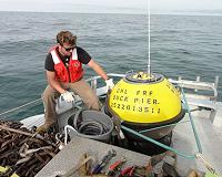
The new wave buoy is deployed 14.5 km offshore in 55 feet of water, and contains high-resolution water level sensors that collect wave climatology and water level information used in evaluating future erosional hot spots and areas of nearshore shoaling.
"The monitoring program will add to the knowledge base regarding barrier island dynamics and sand transport patterns in our complex, multi-barrier island system – a 'region' which besides NASA includes a national seashore, wildlife refuge, Federal navigation project (Chincoteague inlet), and a local economy based largely on coastal tourism. All of which are entities whose continued viabilities are inextricably linked to the region's need to gain a better understanding of the physical processes occurring within it." said Josh Bundick, Institutional program manager.
In addition, the buoy will confirm nearshore sediment transport patterns, which will assist NASA in planning and budgeting for future beach replenishment projects. The buoy provides real-time data available via the internet here.
The buoy is part of the Wallops Island Long-Term Monitoring Program, initiated in 2015, a collaborative effort among Wallops' Facilities Management Branch, Wallops' Environmental Office and United States Army Corps of Engineers (USACE).
The collaborative team surveys and maps onshore and offshore profiles of Wallops Island and portions of adjacent barrier islands. A total of 114 cross sections are surveyed in the fall and 64 cross sections are surveyed in the spring.
"Through long-term collection and analysis of data, NASA will establish trends of how the beach sand is moving, allowing us to assess the performance of our past renourishment project and adaptively manage our shoreline moving forward," said John Saecker, project manager.
Collaborators on the buoy project included the USACE, Norfolk District, Norfolk, Virginia; Coastal and Hydraulics Laboratory, Vicksburg, Mississippi; and Field Research Facility, Duck, North Carolina.
