|
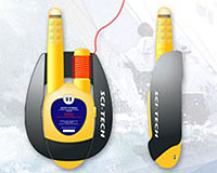
Paris, France (ESA) Jan 22, 2009 Rescuing crew that have fallen overboard in bad weather is fraught with difficulty. Handling the boat and returning to a position close enough to the person is not always easy, especially when operating under stressful conditions. A new system proposes to use satellite navigation to locate the precise position of casualties, and ultimately save lives. Peter Hall and Christine Edwards, both of British start-up company Sci-Tech Systems, have come up with a scheme to help save lives using the Global Navigation Satellite System (GNSS). Named Person Overboard (POB), the system provides real time monitoring of the casualty's position, enabling an immediate and more efficient local rescue. The operation has been enhanced by an original design created by London Associates.
Best chance of survival is rescue by own crew "A fast rescue is important, especially if the casualty is in cold or freezing water when survival time is short." "There are systems which can record the GPS position of where the person has fallen overboard. However if you have a cross tide of 3 knots, then after 15 minutes, which is the time it might take to turn the boat around, the person can already be half a mile down tide. So when you are back to the recorded GPS position, you are half a mile away from the casualty." The system is composed of a crew unit and a ship unit. All crew members onboard wear a crew unit in their lifejacket, which deploys and starts transmitting its position when the person falls overboard. The ship unit receives and feeds this position into the standard onboard navigation equipment, which then guides the crew back to the casualty's position. "The moment the person falls over, the unit signals that a crew member is in the water. It receives GNSS signals and transmits the exact position back to the boat. Because it is transmitted to the boat and the distance is not great, the power required is considerably less than that required to send a signal to a satellite. We should therefore be able to package it well and get a small and easy to wear unit the size of a mobile phone," explains David Lewin, Business and Marketing at Sci-Tech Systems. "The product design is also the key to the success of the system", adds Christine Edwards, Technical Director of Sci-Tech Systems. "The innovative industrial design of the POB, which was created by Will Bentall of London Associates, ensures that it will float upright in rough seas, essential for good radio communications with the ship." The accuracy of both the boat and the casualty's position is critical since rescue will usually be attempted in bad weather conditions, possibly at night, with little or no visual contact with the person in the water. Initially the system is planned to operate using GPS signals, with improved accuracy provided by EGNOS. In the future it will operate with Galileo in order to take advantage of its higher accuracy. As experienced sailor David Lewin emphasises, "The idea to display the position of the crew member in the water on equipment that is being used all the time on a ship is a very important element. As leisure sailors, we spend our days and nights staring at a GPS receiver." "When a person goes overboard and we have a casualty situation, we will know exactly what to do because we know the equipment. It will give us all the information we need to get to where the person is in the water." "When panic strikes and one must do the right thing under the extreme stress of an emergency, it is important that the crew be using equipment that they are very familiar with," emphasises David Lewin. As the POB unit will transmit the location of the person in the water back to the ship unit on an open radio frequency, the signal can be automatically picked up by any other boat in the area using the same equipment. This is a great advantage in some situations, for example in a fishing fleet or a sailing race, where all boats can cooperate and look for the casualty together.
Person overboard idea wins two international prizes "The status of the system is that all the circuitry is known and we have tested all the concepts. We need some help from an antenna manufacturer and a chip manufacturer to make it small, and to bring down battery consumption. We are also looking for a funding partner for the next stage," says Christine Edwards. "We should be able to get our POB system to the market within 12 to 18 months." The system is targeted at commercial fishing boats, merchant shipping, offshore exploration (oil rigs), passenger vessels, and the leisure yachting market. Related Links Sci-Tech Systems Galileo ESA Technology Transfer Programme Office (TTPO) The latest information about the Commercial Satellite Industry
 Paris, France (ESA) Jan 14, 2009
Four teams of postgraduate students have been selected to fly their experiments during a new ESA programme called 'Fly Your Thesis!'. |
|
| The content herein, unless otherwise known to be public domain, are Copyright Space.TV Corporation. AFP and UPI Wire Stories are copyright Agence France-Presse and United Press International. ESA Portal Reports are copyright European Space Agency. All NASA sourced material is public domain. Additional copyrights may apply in whole or part to other bona fide parties. Advertising does not imply endorsement, agreement or approval of any opinions, statements or information provided by Space.TV Corp on any Web page published or hosted by Space.TV Corp. Privacy Statement |