 |
Geneva (AFP) Aug 25, 2009 Google has agreed to examine concerns about privacy on the new "Street View" facility on its online map of Switzerland, the Swiss data protection watchdog said on Tuesday. Federal data protection and transparency officer Hanspeter Thuer said after meetings with representatives of the US Internet giant that they would report back within a week on "if and how the product can be improved swiftly." Thuer's office said in a statement that he was "expecting concrete proposals." The Street View facility allows users to get a ground level panoramic view of some locations on Google Maps, based on still photographs taken by specially-equipped vehicles. Thuer complained last week that some faces or vehicle registration plates in Switzerland had not been wiped out or were insufficiently blurred, allowing people to be identified. He had demanded that it be shut down while Google dealt with the problem. In a statement, Google welcomed the "constructive discussions" with the data protection official and continued dialogue. "We have agreed to cooperate with the federal data protection officer in order to demonstrate the efficiency of our blurring technology and to discuss his misgivings," a spokesman for Google added. Google said volume has increased 80 percent on Google Maps for Switzerland since Street View was introduced. The data protection office said it has received 300 complaints while more had been sent to local authorities. Thuer said he wanted to hear of any complaints directly, but also backed Google's call urging offended browsers to click on the onscreen "report a problem" link. Share This Article With Planet Earth
Related Links Earth Observation News - Suppiliers, Technology and Application
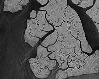
 TerraSAR-X Image Of The Month: Mangroves, Bakassi Peninsula, Cameroon
Bonn, Germany (SPX) Aug 25, 2009 The image, taken by the German radar satellite TerraSAR-X, shows the mangrove-covered islands of the Bakassi peninsula, which are situated at the extreme eastern end of the Gulf of Guinea. Due to the outstanding accuracy of its calibration, TerraSAR-X is able to detect very small changes in the returned signal caused by changes in vegetation or deforestation. By monitoring endangered ... read more |
|
| The content herein, unless otherwise known to be public domain, are Copyright 1995-2009 - SpaceDaily. AFP and UPI Wire Stories are copyright Agence France-Presse and United Press International. ESA Portal Reports are copyright European Space Agency. All NASA sourced material is public domain. Additional copyrights may apply in whole or part to other bona fide parties. Advertising does not imply endorsement,agreement or approval of any opinions, statements or information provided by SpaceDaily on any Web page published or hosted by SpaceDaily. Privacy Statement |