 |
Greenbelt MD (SPX) Feb 04, 2011 Punxsutawney Phil predicted that spring will come on time, and NASA satellite data suggests that residents in more than one-third of the U.S. are now anxious for the prediction to come true. A massive winter storm touched 30 states over the last couple of days, including Phil's home at Gobbler's Knob in Punxsutawney, Pa. where rain mixed with sleet and freezing rain this morning before it changed to snow as part of that system. Phil's town is about 80 miles northeast of Pittsburgh. Looking at the satellite data, it's more than likely that the cloud cover and wet weather prevented the famous groundhog from seeing his shadow. Regardless, tradition says that spring will arrive on time. Satellite imagery from the Geostationary Operational Environmental Satellite called GOES-13 keeps a constant eye on the weather over the eastern U.S. The two GOES satellites that monitor weather over the U.S., the other being GOES-11 covering the western U.S., are both operated by NOAA. Images and animations using the satellite data are created by the NASA GOES Project at NASA's Goddard Space Flight Center in Greenbelt, Md. In a GOES-13 satellite image taken at 1731 UTC (12:31 p.m. EST) on Feb. 2, 2011 there were still clouds over Punxsutawney, Pa. and they were still bringing light snow to the town during the afternoon, hours after the groundhog's famous prediction. The satellite image also showed the most of the thicker clouds were already exiting New England and were bringing Boston, Mass. light rain, mist and fog and while Portland, Maine was getting light snow. The National Weather Service (NWS) indicated that yesterday, Feb. 1, Chicago experienced a record snowfall of 13.6 inches. According to reports from the Weather Channel by 7 a.m. CST on Feb. 2, there was more than 17 inches of snow on the ground who mentioned it was the fifth all time biggest snow storm on record for the city. In Saint Louis, Mo. the NWS reported a record 17.5 inches of snow yesterday and 13.2 inches in Tulsa, Okla. The NWS reported that Milwaukee, Wis. received 8.5 inches on Feb. 1, but a blizzard warning was still in effect during the morning of Feb. 2. In the forecast discussion for Milwaukee, the NWS called it an "historic groundhog blizzard [that is] paralyzing southeast Wisconsin," as winds were gusting as high as 45 mph yesterday and today. The monster winter storm that created these records is now exiting New England and the GOES-13 satellite is tracking its movement. As GOES-13 continues to watch for the next winter storm, there's hope that the groundhog made an accurate prediction.
Share This Article With Planet Earth
Related Links NASA/Goddard Space Flight Center Earth Observation News - Suppiliers, Technology and Application
 Traffic Monitoring With TerraSAR-X/TanDEM-X Satellite Constellation
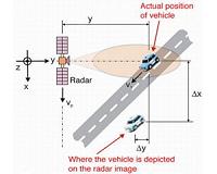
Bonn, Germany (SPX) Jan 31, 2011 Traffic monitoring from space, day and night, from more than 500 kilometres up above; is that possible? Indeed it is! In fact, it has been demonstrated several times in the past - once with the Shuttle Radar Topography Mission (SRTM), and again with TerraSAR-X. The traffic processors used with SRTM and TerraSAR-X were and are still subject to considerable limitations. To determine vehicle ... read more |
|
| The content herein, unless otherwise known to be public domain, are Copyright 1995-2010 - SpaceDaily. AFP and UPI Wire Stories are copyright Agence France-Presse and United Press International. ESA Portal Reports are copyright European Space Agency. All NASA sourced material is public domain. Additional copyrights may apply in whole or part to other bona fide parties. Advertising does not imply endorsement,agreement or approval of any opinions, statements or information provided by SpaceDaily on any Web page published or hosted by SpaceDaily. Privacy Statement |