 |
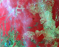
Guildford, UK (SPX) Jun 04, 2009 DMC International Imaging has won a 100,000 euro contract from the European Space Agency (ESA) to demonstrate the value of its coordinated multi-satellite optical imagery for tropical forest monitoring in Indonesia. There is an urgent need for the monitoring of global forests with varying spatial resolutions and regularity, and Earth Observation techniques can make a major contribution. Up-to-date information is vital to improve the effective management of forests and control carbon emissions under the Kyoto strategy for combating climate change. The objective of this project is to demonstrate the benefits of a multi-sensor approach for systematic wide area monitoring of tropical forests at high resolution, exploiting the unique capabilities of the DMC constellation along with complementary data from synthetic aperture radar (SAR) satellites which have all-weather acquisition capabilities. Systematic monitoring of tropical forests over wide areas is currently only done at low resolution. Many aspects of forest management and monitoring require high resolution products, for example to detect selective forest degradation (as opposed to large-scale clearcuts) and the appearance of new logging tracks, and this is why the project will showcase the powerful combination of wide area coverage (each image up to 650km wide) and high resolution (20-32m pixel size) provided by the DMC constellation. The project will demonstrate the ability to detect annual changes (and just as importantly the absence of change) in forest cover associated with logging, protection, re-afforestation schemes and other causes of change. For example, in the last twelve years, Indonesia has suffered from multiple forest and peat soil fires. This is due in part to continued land clearance by local farmers and government projects but they are worsened in El Nino years by the low rainfall. The El Nino effect has created a tinderbox that destroyed more than 9.7 million hectares of forest area in 1997-1998. The result has been the continued degradation of thick peat soils through fire and erosion. Fires such as these are not only dangerous to Indonesia but also to surrounding countries such as Australia because of the poisonous smoke and smog released. It is not only a tragedy for the Asia-Pacific area however, studies have found that the effects of biomass burning activity in Indonesia have made a significant contribution to atmospheric carbon. DMCii leads a team comprising the University of Leicester and the World Resources Institute (WRI) to demonstrate the integration of EO products with non-EO data and expert knowledge to provide a service that integrates with existing users' systems. The team has a wealth of experience: the experts from Leicester University have a long track record of research into peat fires in Indonesia and the World Resources Institute is active in tropical forest monitoring through its Global Forest Watch programme. DMCii has coordinated imaging campaigns over the rainforests of the Amazon Basin, the CongoBasin and South East Asia, and temperate forests in Siberia, Scandinavia, Europe and North America. Satellite imagery from the DMC constellation of 5 small earth observation satellites will be an integral part of the campaign. The constellation, which is soon to gain three new 20 metre class satellites, is ideally suited to regular and wide area imaging because it has the capability to image a wide image swath (650km) at high resolution (32m) on a daily basis which has not been previously available with Landsat ETM data. The three new DMC satellites will further increase the achievable resolution to 20m, offering much more detailed imagery. This project focuses on private sector and NGO users such as forest management, certification and carbon trading but the results will also be relevant for various public sector initiatives. Share This Article With Planet Earth
Related Links DMC International Imaging Earth Observation News - Suppiliers, Technology and Application
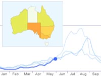 Google tool tracks flu in Australia, New Zealand
Washington (AFP) June 3, 2009 Google on Wednesday expanded "Google Flu Trends," its online tool for tracking influenza outbreaks, to Australia and New Zealand. Google said it had built a flu model for the state of Victoria by working with its own search data and historical flu data from the Victorian Infectious Diseases Reference Laboratory. "We then extrapolated this model to produce flu models at a national and ... read more |
|
| The content herein, unless otherwise known to be public domain, are Copyright 1995-2009 - SpaceDaily. AFP and UPI Wire Stories are copyright Agence France-Presse and United Press International. ESA Portal Reports are copyright European Space Agency. All NASA sourced material is public domain. Additional copyrights may apply in whole or part to other bona fide parties. Advertising does not imply endorsement,agreement or approval of any opinions, statements or information provided by SpaceDaily on any Web page published or hosted by SpaceDaily. Privacy Statement |
 del.icio.us
 Digg
Digg Reddit
 YahooMyWeb
 Google