 |
Paris, France (ESA) May 24, 2010 ESA's SMOS satellite completed its six-month commissioning this week and formally began operational life. This milestone means the mission is now set to provide much-needed global images of soil moisture and ocean salinity to improve our understanding of the water cycle. The Soil Moisture and Ocean Salinity (SMOS) satellite was launched on 2 November last year, and has since undergone an intense programme of calibration and commissioning in preparation for its life in service. At a three-day review this week in �vila, Spain, all the elements of the mission were found to be in excellent shape. The meeting concluded with the formal end of commissioning. Responsibility for the mission has now been transferred from ESA's Project Manager, Achim Hahne, who held the reins since the mission was selected in 2001 for development, to Susanne Mecklenburg, ESA's SMOS Mission Manager, who is responsible for the data and its delivery to the scientific community. Achim Hahne said, "I would like to thank all my colleagues in ESA, CNES and industry for their excellent work in taking this mission off the drawing board and into orbit. "It's been a privilege to have worked on this novel mission, which not only provides essential information to help further our understanding of the Earth system, but also demonstrates the excellence of European technology. "From now on, our baby will be the in capable hands of Susanne and we look forward to seeing how SMOS's eagerly awaited data will contribute to Earth science and be used in practical applications." SMOS employs a novel interferometric radiometer that operates in the L-band microwave range to capture 'brightness temperature' images. These images are used to produce global maps of soil moisture every three days and maps of ocean salinity averaged over 30 days. By consistently mapping these two variables, SMOS will advance our knowledge of the exchange processes between Earth's surface and atmosphere and also help to improve weather and climate models. In addition, the data will also be used for practical applications in areas such as agriculture and water resource management. Susanne Mecklenburg said, ''So far, the mission has been progressing really well and we have been very happy to see what the scientific community has already been able to achieve with the data. Brightness temperature data will be released in June and soil moisture and ocean salinity data will be available in September after further validation." ESA has placed three of its Earth Explorer satellites in orbit within a little over 12 months. The GOCE gravity mission was launched in March 2009, followed by SMOS in November and the CryoSat ice mission last month. Results from these three missions will be presented to the scientific community at the Living Planet Symposium at the end of June in Bergen, Norway.
Share This Article With Planet Earth
Related Links SMOS Earth Observation News - Suppiliers, Technology and Application
 MISR Provides Unique Views Of Gulf Oil Slick
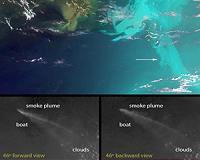
Pasadena CA (JPL) May 24, 2010 These unique images of the Deepwater Horizon oil slick in the Gulf of Mexico were obtained by the Multi-angle Imaging SpectroRadiometer (MISR) instrument aboard NASA's Terra spacecraft on May 17, 2010, at around 16:40 UTC (11:40 a.m. CDT). The top panel is a false-color image created by combining data from the red band of the 26-degree forward-viewing camera (where the oil appears dark) wi ... read more |
|
| The content herein, unless otherwise known to be public domain, are Copyright 1995-2010 - SpaceDaily. AFP and UPI Wire Stories are copyright Agence France-Presse and United Press International. ESA Portal Reports are copyright European Space Agency. All NASA sourced material is public domain. Additional copyrights may apply in whole or part to other bona fide parties. Advertising does not imply endorsement,agreement or approval of any opinions, statements or information provided by SpaceDaily on any Web page published or hosted by SpaceDaily. Privacy Statement |