 |
Washington DC (SPX) May 28, 2010 Two NASA satellites are capturing images of the oil spill in the Gulf of Mexico, which began April 20, 2010, with the explosion of the Deepwater Horizon oil rig. This series of images reveals a space-based view of the burning oil rig and the ensuing oil spill, through May 24. The imagery comes from the MODIS instruments aboard NASA's Terra and Aqua satellites. The oil slick appears grayish-beige in these images. The shape of the spill changes due to weather conditions, currents and the use of oil-dispersing chemicals.
Share This Article With Planet Earth
Related Links Full oil spill image archive NASA's Oil Spill website NASA's Earth Observatory Natural Hazards website Earth Observation News - Suppiliers, Technology and Application
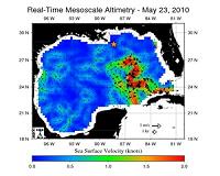
 NASA Satellites Keep Watch On Gulf Current Near Spill
Pasadena CA (JPL) May 26, 2010 Scientists and agencies monitoring the oil spill in the Gulf of Mexico are keeping a wary eye on changes in the nearby Loop Current, a warm ocean current that is part of the Gulf Stream. Beginning as a large flow of warm water from the Caribbean, the Loop Current heads up into the eastern part of the Gulf of Mexico and then turns south before finally moving out through the Straits of Flori ... read more |
|
| The content herein, unless otherwise known to be public domain, are Copyright 1995-2010 - SpaceDaily. AFP and UPI Wire Stories are copyright Agence France-Presse and United Press International. ESA Portal Reports are copyright European Space Agency. All NASA sourced material is public domain. Additional copyrights may apply in whole or part to other bona fide parties. Advertising does not imply endorsement,agreement or approval of any opinions, statements or information provided by SpaceDaily on any Web page published or hosted by SpaceDaily. Privacy Statement |